|
|
Post by OziRiS on Jun 30, 2014 7:31:09 GMT
I'd at least like to think that scientifically surveying and measuring an area to give as complete and accurate a depiction of what that area looks like is a tad more precise than "Eeerm... Yeah, I think you need to take a left on *BLAH* Drive, go past the McNope's and take a right. Or is it a left...? I forget... Anyway, it's down thataways somewehere." when you follow the instructions from mapquest and find yourself looking at your destination in your rear view mirror, you will figure out the error in that assumption. Never having used Mapquest, I wouldn't know. I thought we were talking about paper road maps, not the online things. |
|
|
|
Post by silverdragon on Jun 30, 2014 8:05:17 GMT
Map quest, how to get "Lost" and take roads you shouldnt take.
This is the type of map service that takes no notice of wide long high vehicles and will sned you down urban side roads meant only for residents.
Google earth is a better bet, at least that way you can "see" what type of road it is.
|
|
|
|
Post by the light works on Jun 30, 2014 14:56:53 GMT
when you follow the instructions from mapquest and find yourself looking at your destination in your rear view mirror, you will figure out the error in that assumption. Never having used Mapquest, I wouldn't know. I thought we were talking about paper road maps, not the online things. paper maps do not guarantee competency at map reading. |
|
|
|
Post by OziRiS on Jun 30, 2014 18:08:59 GMT
Never having used Mapquest, I wouldn't know. I thought we were talking about paper road maps, not the online things. paper maps do not guarantee competency at map reading. Good directions from a stranger does not guarantee competency at following directions. If you can't tell left from right or your ass from your elbow, you're F'ed either way. |
|
|
|
Post by the light works on Jun 30, 2014 19:06:39 GMT
paper maps do not guarantee competency at map reading. Good directions from a stranger does not guarantee competency at following directions. If you can't tell left from right or your ass from your elbow, you're F'ed either way. true, so you get a person skilled at soliciting and following directions up a against a person skilled at reading maps. |
|
|
|
Post by OziRiS on Jun 30, 2014 20:36:40 GMT
Good directions from a stranger does not guarantee competency at following directions. If you can't tell left from right or your ass from your elbow, you're F'ed either way. true, so you get a person skilled at soliciting and following directions up a against a person skilled at reading maps. And you'd still run into the problem that no matter how skilled you are at following directions, they have to be correct in the first place to get you where you're going. The odds of a map being correct are a lot higher. |
|
|
|
Post by the light works on Jun 30, 2014 20:45:34 GMT
true, so you get a person skilled at soliciting and following directions up a against a person skilled at reading maps. And you'd still run into the problem that no matter how skilled you are at following directions, they have to be correct in the first place to get you where you're going. The odds of a map being correct are a lot higher. however, the odds of your map being outdated are also substantially higher. and of course, the fact that we can debate this indicates it is something that is not certain. example: try finding Pelican Court on a map of Lincoln City. (note that I agree with you that proper use of a map will usually get you better data, though there are also occasions where directions are more useful. my contention is that it is possible that proper use of directions may be able to filter the information more effectively than trying to use the map.) |
|
|
|
Post by OziRiS on Jun 30, 2014 21:08:23 GMT
And you'd still run into the problem that no matter how skilled you are at following directions, they have to be correct in the first place to get you where you're going. The odds of a map being correct are a lot higher. however, the odds of your map being outdated are also substantially higher. and of course, the fact that we can debate this indicates it is something that is not certain. example: try finding Pelican Court on a map of Lincoln City. (note that I agree with you that proper use of a map will usually get you better data, though there are also occasions where directions are more useful. my contention is that it is possible that proper use of directions may be able to filter the information more effectively than trying to use the map.) I've found that a combination of the two approaches (when the map fails to get you all the way there) usually works. Use the map to get close enough to your destination that you're more likely to actually meet someone who's local enough to know the rest of the way. But that, again, points toward my theory of waypoint directions possibly being better than full directions, depending on the distance you're travelling. Being closer to your final destination increases the odds of meeting someone who knows the area well enough to actually give useful directions. |
|
|
|
Post by silverdragon on Jun 30, 2014 22:33:50 GMT
My Son told me he knew how to read a map.
We had a challenge.
He asked me to put the map the right way up and find "North"... we were in the middlle of nowhere at the time, I was not to use a compass.
I put it straight up.
How?.. I "Orientated" by using the Church-with-a-spire in the distance.... and it was very easy to find where I was on that map...
He didnt know the OS Map sign for a church with a spire?...
Yet he can "Read" a map?...
Using obvious land marks, I though that was the first lesson in map reading.
|
|
|
|
Post by the light works on Jun 30, 2014 22:54:31 GMT
however, the odds of your map being outdated are also substantially higher. and of course, the fact that we can debate this indicates it is something that is not certain. example: try finding Pelican Court on a map of Lincoln City. (note that I agree with you that proper use of a map will usually get you better data, though there are also occasions where directions are more useful. my contention is that it is possible that proper use of directions may be able to filter the information more effectively than trying to use the map.) I've found that a combination of the two approaches (when the map fails to get you all the way there) usually works. Use the map to get close enough to your destination that you're more likely to actually meet someone who's local enough to know the rest of the way. But that, again, points toward my theory of waypoint directions possibly being better than full directions, depending on the distance you're travelling. Being closer to your final destination increases the odds of meeting someone who knows the area well enough to actually give useful directions. I definitely agree that waypoint directions are the best strategy. when I respond to calls at an unfamiliar address, I pull up the map on my CAD (computer aided dispatch) app, check the area, and then "sleep" the phone until I get close. at that point, I can double check the address, or activate GPS navigation. (I've also been known to write the apartment number on my "palm pilot" and to make remarks about camouflaged house numbers) |
|
|
|
Post by the light works on Jun 30, 2014 22:58:45 GMT
My Son told me he knew how to read a map. We had a challenge. He asked me to put the map the right way up and find "North"... we were in the middlle of nowhere at the time, I was not to use a compass. I put it straight up. How?.. I "Orientated" by using the Church-with-a-spire in the distance.... and it was very easy to find where I was on that map... He didnt know the OS Map sign for a church with a spire?... Yet he can "Read" a map?... Using obvious land marks, I though that was the first lesson in map reading. I make a habit of orienting maps and blueprints with the subject matter, rather than arbitrarily facing north away from me. not sure if it is right or wrong, but it helps my visualization. |
|
|
|
Post by OziRiS on Jul 1, 2014 0:29:53 GMT
My Son told me he knew how to read a map. We had a challenge. He asked me to put the map the right way up and find "North"... we were in the middlle of nowhere at the time, I was not to use a compass. I put it straight up. How?.. I "Orientated" by using the Church-with-a-spire in the distance.... and it was very easy to find where I was on that map... He didnt know the OS Map sign for a church with a spire?... Yet he can "Read" a map?... Using obvious land marks, I though that was the first lesson in map reading. I make a habit of orienting maps and blueprints with the subject matter, rather than arbitrarily facing north away from me. not sure if it is right or wrong, but it helps my visualization. "The right way" is to always have the map facing north, regardless of which way you're facing. That automatically aligns the map with the subject matter. You're aligning the map with the subject matter, automatically facing it north in the process, so you're not doing it wrong. You're just doing it backwards and getting the same result  |
|
|
|
Post by the light works on Jul 1, 2014 0:44:58 GMT
I make a habit of orienting maps and blueprints with the subject matter, rather than arbitrarily facing north away from me. not sure if it is right or wrong, but it helps my visualization. "The right way" is to always have the map facing north, regardless of which way you're facing. That automatically aligns the map with the subject matter. You're aligning the map with the subject matter, automatically facing it north in the process, so you're not doing it wrong. You're just doing it backwards and getting the same result just describing it backwards. |
|
|
|
Post by silverdragon on Jul 2, 2014 9:35:26 GMT
I was just keeping it simple.
I know where I am, I know where the church is, what else do I need?...
Is there a right or wrong way where the simple way is easier, and correct?
To me, with a lot of outdoors sport and stuff, as long as its within the law, its not about right or wrong, its what works, and whats simple.
I could have used a third point of reference, the large hill to one side, but that would be showing off?...
|
|
|
|
Post by c64 on Jul 23, 2014 10:10:58 GMT
GPS is only as good as the information it is loaded with, and as more than a few cases have shown bad information can result in everything from a GPS trying to send 18 wheeler trucks down streets they can't physically fit in, to ending up in a lake. In any case, even if we assume that the GPS is up to date it could act as the control. It would also mean three different navigation types...one for each of the build team. The early GPS data was converted from ordinary maps. The problem was that a 2D map doesn't anticipate a 3D terrain. A 2D map can never add up and is averaged to make everything fit. This gives the GPS unit false distances between the nodes (a node is a bend in the road or an intersection). Also not every bend in the road has its own node on 2D map material. Modern GPS maps are not like the old 2D map material at all. The data comes from actual driving the roads with a GPS receiver numerous times. The first GPS units I had examined used a 512MB memory and held the whole country of Germany. My current unit has a full 16GB card for "western Europe" and the data is compressed. The "Germany" file alone is 3.4GB so it contains much more than 4 times the information of an early GPS unit. The modern GPS units also know the speed limits of the roads so they can calculate which roads are faster than others. My unit also knows where traffic lights are and it often suggests a parallel course which can't be driven as fast as the main roads but steady which gives me a greater average speed. Also I have subscribed for TMC+. TMC is an European system which broadcasts digital traffic data on FM radio stations. When the GPS unit is on for a while, it has gathered enough data about closed roads, construction sites and traffic jams to calculate a much faster route. And TMC+ is even better. The Deutsche Telekom monitors the position of their cell phones and match the positions and speed of the cell phones with the roads. So they know how fast their cell phone customers move on the roads and this information is sent to my unit by TMC+. So my GPS unit knows the actual speed I could drive on all roads and calculates the fastest route for the current traffic situation. TMC+ is really fast with updates! A friend was right behind a bad accident and when he had dialed "112", he checked his TMC+ unit for his exact position and the traffic jam was already displayed on his unit. So the Telekom had monitored dozens of cell phones stopping out of a sudden and reported it over the TMC+ system before anyone could summon an ambulance. But TMC isn't secure at all. It will accept any FM transmitter with TMC data and there is no security built in. ANybody can broadcast TMC data... www.theregister.co.uk/2012/05/25/air_raid_warning/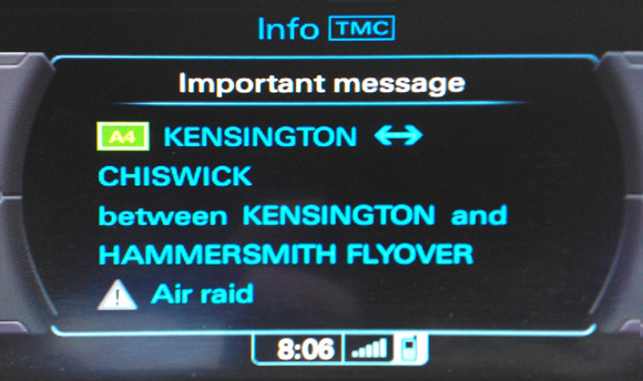 |
|
|
|
Post by Cybermortis on Jul 23, 2014 13:21:09 GMT
Which doesn't explain how Adam Savage's GPS system didn't know he was driving across SF bay on a bridge. Instead it seemed to think he was flying and was (if memory serves) trying to redirect him to the Golden Gate bridge.
|
|
|
|
Post by c64 on Jul 23, 2014 14:19:52 GMT
Which doesn't explain how Adam Savage's GPS system didn't know he was driving across SF bay on a bridge. Instead it seemed to think he was flying and was (if memory serves) trying to redirect him to the Golden Gate bridge. This is not a map data problem. This problem is caused by bad GPS reception and a poor software design of the GPS unit. The dad of a friend had bought a cheap GPS unit in a grocery store two years ago. Just turn it on in your living room and enjoy the trip. Indoors, it will give you a tour in a 30 miles radius. I own a rather expensive unit and even if it's relative old now (6 years or so), it is either highly accurate or at least tells you that it is guessing. It has a built in compass and is connected to the speedometer. It works well even in tunnels and between tall buildings. In unmapped areas like forests, parking lots and on race tracks, it draws a dotted line you can use to return back to the public roads. I even have an accurate map of the Nürburgring in it because if you repeat driving in an uncharted area, it makes its own map. |
|